Greenland is a massive, mainly ice-covered island that stretches north from the Atlantic Ocean up to the Arctic Ocean.
Greenland is known for its immense glaciers.
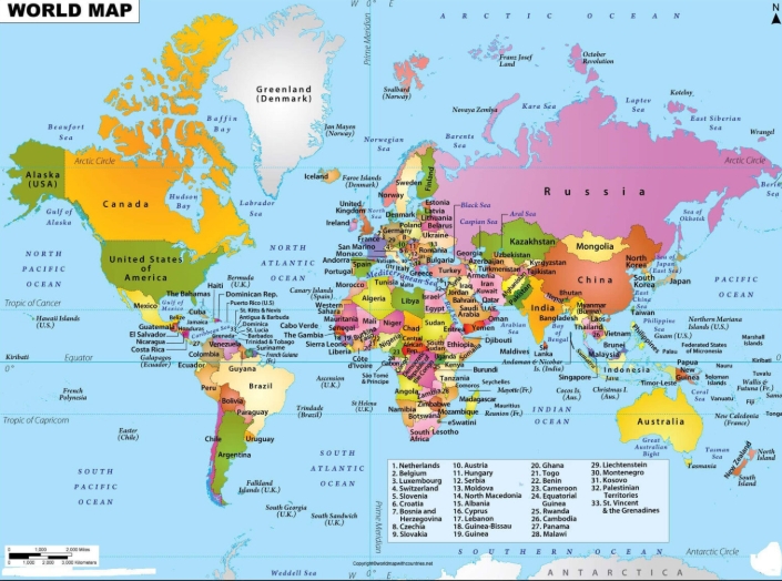
Greenland, the world’s largest island, sits in the North Atlantic Ocean and is a territory of Denmark. It’s over three times bigger than Texas, with Canada’s Ellesmere Island just 16 miles (26 kilometers) to the north. Its closest European neighbor is Iceland, about 200 miles (321 kilometers) to the southeast.
About two-thirds of Greenland sits above the Arctic Circle, giving it a freezing climate all year long. In summer, residents enjoy 24 hours of daylight, though temperatures only climb to around 40°F (4°C). In winter, nearly constant darkness sets in, with temperatures dropping to as low as -30°F (-34°C).
The Arctic climate supports the island’s enormous ice sheet, a vast expanse of glacier ice that covers about 80 percent of the land. The Greenland Ice Sheet is the world’s second largest after Antarctica’s, stretching more than 1,500 miles (2,400 kilometers) from north to south and reaching nearly 5,000 feet (1,524 meters) thick in many areas—almost a mile deep in some spots!
The parts of Greenland not covered in ice are blanketed by tundra, a flat, treeless expanse often swept by strong winds. Even here, ice lingers in the form of permafrost, or frozen soil, beneath much of the ground. The island’s coastline is mostly rocky—and there’s plenty of it. Stretched out like a string, it would span 24,430 miles (39,330 kilometers), nearly enough to circle the Earth at the Equator.
NATURE
Greenland’s natural landscape is defined by its harsh Arctic climate, with most of its plant life found on the tundra beyond the ice sheets. The tundra is home to low-growing vegetation like dwarf birch and whortleberry, along with mosses and lichens scattered across the terrain.
The waters around the island are home to marine mammals like seals, walruses, and whales. On the ice sheets, you might spot polar bears, arctic foxes, wolves, reindeer, and musk oxen wandering about. Along the coast, around 230 bird species gather, including sea eagles that feast on saltwater fish such as salmon, flounder, and halibut.
Almost half of Greenland is preserved as the National Park of Greenland—its only national park and the largest in the world. Spanning 375,000 square miles (971,245 square kilometers), it covers most of the island’s northeastern region. The park is mainly visited by sealers and whalers from Ittoqqortoormiit, a remote town in eastern Greenland, along with a handful of scientists and military staff.
The North Pole is the furthest north of any place on Earth.
The North Pole is a point on the Northern Hemisphere where the world’s rotational axis meets with the surface of the earth.
Located at the center of the Northern Hemisphere, the North Pole sits north of Greenland, Russia, and Canada. While it isn’t part of any continent, it’s also not considered a continent on its own.
The North Pole is made of only frozen water. There is no land at the North Pole.
The North Pole is part of the Arctic Tundra.
The North Pole is covered with ice year-round.
The sun stays up all summer.
The sun never rises in the winter.
Many types of animals live at the North Pole, including the walrus, seal, Arctic fox, moose, and snowy owl.
Approximately 1,700 species of plants live on the Arctic tundra, including flowering plants, dwarf shrubs, herbs, grasses, mosses, and lichens.
The tundra is characterized by permafrost, a layer of soil and partially decomposed organic matter that is frozen year-round. Only a thin layer of soil, called the active layer, thaws and refreezes each year. This makes shallow root systems a necessity and prevents larger plants such as trees from growing in the Arctic.
Tundra vegetation is characterized by small plants (typically only centimeters tall) growing close together and close to the ground.
The Louisiana Purchase was a land deal made by U.S. President Thomas Jefferson in 1803. He purchased the Louisiana Territory from France, led by Napoleon Bonaparte, for 15 million USD. Initially, the delegates sent to France were authorized to spend up to 10 million USD to acquire New Orleans and possibly the west bank of the Mississippi River. However, the French government offered to sell the entire Louisiana Territory for just 5 million more. Jefferson approved the deal and used his constitutional authority to sign treaties to finalize the purchase.
Napoleon Bonaparte sold the land to fund the Great French War. With the British back in the conflict and France losing the Haitian Revolution, defending Louisiana became impossible. Thomas Jefferson seized the French offer as a chance to expand America, even though it went against his Republican principles of small government—some argue he overstepped his constitutional authority by making the deal on his own.
Louisiana Purchase
A map of the Louisiana Purchase compared to state boundaries in 2025. The Louisiana Purchase is shown in green overtop of what states would be formed from it.
The Lewis and Clark expedition explored the Louisiana Purchase and the Oregon Territory. They started from St. Louis. Their route traced the Missouri River.
Children in the Indus Valley enjoyed playing with toys. Archaeologists discovered clay cows with movable heads, toy monkeys that slid down ropes, small toy carts, various clay animals, and bird-shaped whistles. What might these toys have looked like?
These appear to be toys and games uncovered in the Indus Valley by archaeologists. Are any of them familiar to you?
Dice and chess are two remarkable legacies of the Indus Valley, passed down through generations to become a part of our lives today, thousands of years later!
Archaeologists have discovered moving toys that operated by pulling a string, causing parts of the toy to move. One such toy featured monkeys sliding down ropes. Other examples included wheeled toys that could be pulled along and baby rattles. These toys often reflected their culture, with a strong emphasis on animals, particularly farm animals.
Children likely had numerous chores since survival required constant effort. They were taught to work alongside their parents, learning essential skills such as cooking, hunting, farming, and crafting.
There’s a lot we have to speculate about regarding their civilization. From what we know of other ancient societies, it was common for most children not to attend school. This makes sense, as many children worked alongside their parents. For example, the children of bead-makers wouldn’t have needed the reading skills required of scribes. Scribes, as recorders, were responsible for writing down important records.
The Indus civilization’s economy relied a lot on trade. This trade was made easier by big improvements in transport.
The Indus Valley Civilization might have been the first to use wheeled transport. They likely used bullock carts, which look like those still seen in South Asia today. They also used boats.
Their boats were probably small, flat-bottomed crafts, possibly sail-powered, similar to those seen on the Indus River today. However, there’s also evidence of larger, sea-going vessels. Archaeologists uncovered a massive canal and docking area in Lothal, a coastal city in India. Moreover, an extensive canal network was used for crop irrigation.
Artifacts from the Indus civilization have been discovered in various locations, indicating their extensive trade networks. These networks spanned parts of Afghanistan, the coastal regions of Persia, northern and western India, and Mesopotamia. Analysis of teeth from Harappa burials suggests that some residents originated from outside the Indus Valley. Additionally, there is evidence of trade with Crete and possibly Egypt.
The Harappan and Mesopotamian civilizations had an extensive sea trade network, dating back to the middle Harappan Phase. Long-distance trade flourished with innovative boat designs. These boats were made of planks and featured a single central mast, which supported sails crafted from woven reeds or cloth.
You’ve discovered that the Indus Valley had cities. What can you notice in this picture? It shows the ruins of an ancient Indus Valley city.
The walls were constructed from bricks, likely made of mud and baked to harden. There were roads and towering walls. I can’t help but wonder if that narrow passage stretching from the street to the bottom of the picture was meant for people or water.
They did have narrow streets, but they also dug drains and wells for water.
Some cities had a fortress of sorts, a citadel, a building that was larger and up higher than the others. Maybe that was the place where the ruler lived.
Did most people live in cities? No, the majority were farmers.
Our knowledge of life in the Indus Valley is limited. Most of what we know comes from archaeological findings at sites like the ones mentioned above, while the rest is based on interpretations and educated guesses from the evidence available.
The discovery of crowns suggests that each city likely had its own ruler. The streets in these cities remained unchanged for centuries, preserving a way of life that endured for generations.
The city was surrounded by walls; like those in the Bible, with gates that everyone used to come and go. Guards stood vigilant, ensuring the city’s safety, while the walls provided a solid defense against any enemies.
One of the reasons we know so little about life in the Indus Valley is that their writing remains undeciphered. While other ancient scripts have been decoded, theirs still baffles us, leaving no written records to reveal details of their lives.
Based on various statues and artifacts discovered, it seems they worshipped numerous idols and gods, much like other ancient civilizations.
This statue, unearthed in 1927 and referred to as the “Priest-King,” prompts curiosity about why it is thought he held a position of leadership.
To start, they built a statue of him. He appears well-groomed, adorned with an ornamental headdress, and dressed in a decorative robe. He’s clearly not an ordinary person.
We aren’t sure if they had priests or if the priests were their leaders—it’s just a theory. What we do know is that they had beliefs about the dead. When they buried someone, they included items from their home, possibly food and water, to provide for them.
Photo Credits:
“Priest-King” By Mamoon Mengal (world66.com) [CC BY-SA 1.0], via Wikimedia Commons
“City Planning” By Gaffar772 [CC BY-SA 4.0], from Wikimedia Commons
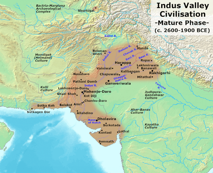
The Indus Valley Civilization was an ancient culture that existed during the Bronze Age. It lasted from about 3300 BC to 1300 BC. Its most important time was between 2700 BC and 1700 BC.
This civilization was located in the Indian subcontinent. It grew along the Indus River and the Ghaggar-Hakra River. Today, these areas are in Pakistan, northwest India, and Afghanistan.
Indus Valley Civilization
Archaeologists first found signs of this civilization in the 1880s. The first city they dug up was Harappa. Because of this, the civilization is also called the ‘Harappan Civilization’.
The Indus Valley Civilization covered a very large area. It stretched from Balochistan in Pakistan to Gujarat in India. The people were skilled builders. Their cities showed clever design and planning. Buildings often had two or more floors. They even had bathrooms connected to the rooms.
One special thing about their cities was their amazing drainage system. Brick-lined drains ran along every street. Some bricks could be removed. This made it easy to clean and check the drains.
Harappan traders used seals on their goods. These seals helped make sure that packages were not opened during travel. We still don’t know how to read their writing system.
In 1842, Charles Masson wrote about the Indus Valley sites. But few people paid attention. Later, in 1921-22, John Marshall led the first big archaeological dig at Harappa.
Here are some images we have from the work of archaeologists. Make observations.
All photographs on this page are in the public domain.
The Roanoke Colony was England’s first attempt at a permanent settlement in North America.
The people of the colony disappeared under mysterious circumstances, leaving behind an empty fort.
The colonists and their bodies were never found.
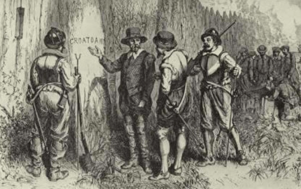
The only clue found was the word, ‘CROATOAN’ carved into Roanoke’s fort palisade.
Hypotheses include that the colonists were taken in or killed by the local Croatan Indians.
John White discovers the word “CROATOAN” carved at Roanoke’s fort palisade by unknown
Lost Colony of Roanoke The Roanoke Colony was England’s first attempt to establish a settlement in the Americas. Sadly, the effort failed when the settlers vanished under mysterious conditions, earning it the nickname “The Lost Colony.”
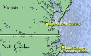
Map showing location of Jamestown and Roanoke Island Colonies by NOAA
Where was the colony located?
The Roanoke Colony was situated on Roanoke Island, just off the coast of what is now North Carolina. At the time, this area was considered part of Virginia.
Early Plans
In 1584, Queen Elizabeth I granted Sir Walter Raleigh the land of Virginia in North America. The British aimed to expand their empire by establishing a presence in the Americas. Raleigh sent Captain Philip Amadas and Captain Arthur Barlowe to explore the region. They came across Roanoke Island and encountered the local natives. Raleigh decided it was an ideal spot to set up a colony.
First Colony at Roanoke
The first expedition to Roanoke was led by Sir Richard Greenville. The expedition arrived at Roanoke in 1585. Greenville left 107 settlers, all men, at Roanoke under the charge of Ralph Lane. Greenville then returned to England in order to gather additional supplies for the settlement.
The settlers built a fort at Roanoke, but struggled to survive. It didn’t help matters that they were constantly fighting with the local Native Americans. When English explorer Sir Francis Drake passed by the settlement and offered to take them back to England, the colonists agreed. Not long after the colonists left, Captain Greenville finally returned with new supplies only to discover that the settlement had been abandoned. He left a small group of men on the island and then returned to England.
Second Colony at Roanoke
A second attempt at starting a colony at Roanoke occurred in 1587. This time 115 colonists travelled to Roanoke led by John White. They hoped to find the men that Greenville had left a year earlier. However, upon their arrival, all they found at the settlement was a human skeleton. Despite this setback, the colonists began to build their settlement on Roanoke. Not long after their arrival, a girl named Virginia Dare was born. She was the first child born in the Americas to English parents.
Unfortunately, the colonists continued to have disputes with the local tribes and some colonists were killed. They also discovered that they were ill-prepared to build a thriving colony. John White decided to return to England in order to gain supplies and reinforcements for the colony.
The Colony has Disappeared
After returning to England, White could find little help for the colony. England was in the middle of a large battle with Spain and the Spanish Armada. As a result, White was unable to return until three years later in 1590. When White arrived he found the colony completely abandoned. The only clues that White found included the word “Croatoan” carved into a fence post and “Cro” carved into a tree.
White found no sign of a struggle, however, and figured that the colonists had moved to Croatoan, which was what they called a nearby island (Hatteras Island). He also had reason to hope because he had told the colonists to carve a Maltese cross if they were being forced leave. Since he found no cross, he figured the colonists were okay. White was unable to search the nearby island for the colonists because of a bad storm and was forced to return to England.
The colonists were never heard from again and the colony gained the nickname the “Lost Colony.”
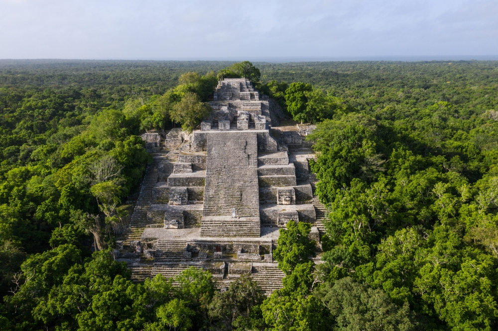
Similar to the Egyptians, the Maya were famous for their pyramids, which differed in shape based on their location. The Mayan pyramids stand as enduring monuments to the remarkable achievements of the ancient Mayan civilization. With their stepped-pyramid design and precise alignments with celestial events, the Mayan pyramids served as centers of worship, and astronomical observatories. The Maya inhabited the Yucatán Peninsula in Mexico.
The civilization dates back to around 1500 BC. Between AD 300 and 900, major ceremonial centers such as Palenque, Tikal, and Copán were mysteriously deserted.
The Mayan religion revolved around the worship of numerous nature gods. Their incredible architecture still stands today as impressive ruins at sites once used for religious ceremonies, such as Palenque, Uxmal, Copán, Tikal, and Chichén Itzá.
Mayan Pyramids Facts
1. Built for religious and ceremonial purposes
Mayan pyramids were central to the religious and cultural life of the Mayan civilization. These sacred structures served as the focal point for religious rituals, ceremonies, and significant community events.
2. Stepped-pyramid design with temples on top
The Mayan pyramids were most commonly built in the stepped-pyramid style, often referred to as “pyramid-temples.” These impressive structures featured multiple levels, each serving a unique function.
A wide staircase ascended to the top platform, where a temple or shrine was built to house sacred artifacts or symbolize a particular deity. The number of steps often varied, reflecting significant numerical values in Mayan cosmology.
3. Aligned with celestial events and the Mayan calendar
The Mayans were talented astronomers and mathematicians with a profound knowledge of celestial cycles. Their pyramids were deliberately designed to align with key astronomical events, including solstices, equinoxes, and the positions of celestial bodies like the sun, moon, and Venus.
These alignments not only played a role in religious and ceremonial practices but also assisted the Mayans in agricultural planning, tracking key calendar dates, and strengthening their bond with the cosmos and their gods.
The accuracy of these alignments showcases the Mayans’ incredible knowledge of astronomy and their talent for creating structures that harmonized perfectly with the natural environment.
4. Constructed with limestone blocks
The Mayan pyramids were mainly constructed with limestone, a sedimentary rock found in abundance throughout the Yucatan Peninsula and other areas where the Mayan civilization thrived. It was a practical choice due to its availability and the ease with which it could be worked.
The Mayans gathered stone from local quarries and carved it into uniform blocks for their buildings. They used lime-based mortar to hold the stones together, ensuring the pyramids stayed stable and lasted through the years.
The Mayans added to the beauty of their structures by plastering the exteriors and painting them in bright, vibrant colors, transforming the pyramids into striking landmarks within their cities.
5. Vary in size based on the city’s importance
The size and design of Mayan pyramids varied based on the significance of the city or site. Bigger and more elaborate pyramids were typically located in major cities with strong political and religious influence.
The grand pyramids represented the city’s power and status, often becoming central hubs for social and religious events.
Smaller settlements or less prominent sites, on the other hand, often had simpler and less grand pyramids, but these structures still held deep religious significance for the local communities.
Chichen Itza, one of the largest sites near Cancun, Mexico, features a massive ball game court, measuring around 150 by 40 feet—bigger than a football field. It’s the largest court in the Mundo Maya. The ball game, that became known as Pok-A-Tok or Pitz to the Maya, was a popular activity among all Mesoamerican peoples and originated around 3,000 B.C., serving a ritualistic purpose for the ancient Maya.
The game is featured in many myths, often representing the struggle between deities of day and night or the clashes between sky gods and underworld rulers. The ball symbolized celestial bodies like the sun, moon, or stars, while the rings represented sunrise, sunset, or equinoxes.
There were two teams, and the number of players varied depending on the region where the game was played. Most ball courts featured two sloping parallel walls with three round disks known as markers or a single stone ring positioned at right angles to the ground.
hoop in ball court at Chichen Itza
The players scored by touching the markers or passing the ball—which was 50 centimeters in diameter and weighed more than two pounds—through the rings. The markers or rings were several yards above the ground, and the players could only touch the ball with their elbows, knees, or hips. Scoring was considered such a feat that it usually ended the game.
These games could go on for days. The losing team was usually sacrificed.


